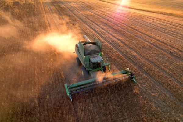
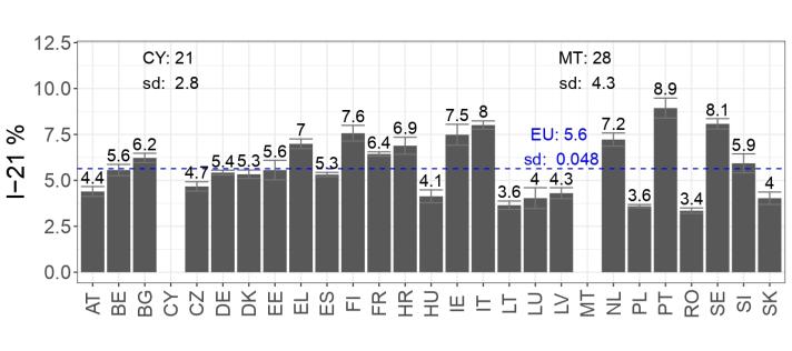
A survey of landscape features coverage in agricultural land across the EU shows these areas account for 5.6% of agricultural land. The most common features are woody areas, which account for 3.2% of the total, followed by grassy areas (1.9%), wet areas (0.4%), and stony regions (0.2%), according to a JRC study.
Landscape features can include hedges, ponds, ditches, or small wooded areas. These are all non-productive components of agricultural land. Yet, their role is fundamental to boost biodiversity and to support ecosystem services.
These findings are published in a study that estimates landscape features at EU and country level, based on Land Use/Cover Area Frame Survey (LUCAS). LUCAS is a survey that provides harmonised and comparable statistics on land use and land cover across the whole of the EU’s territory. The data collected from this survey plays a crucial role in supporting the common agricultural policy (CAP) and the recently agreed Nature Restoration Law (NRL).
The distribution of landscape features varies widely across the EU, with coverage ranging from 3.4% to 8.9% in most countries. Countries like Greece, Finland, Ireland, Italy, the Netherlands, Portugal, and Sweden are on the upper side of the range, from 7% to 9%; while Malta and Cyprus are even above 9%.
Supporting CAP and environmental policies
Protection of biodiversity, enhancement of ecosystems, preservation or restoration of habitats and landscapes – all of these are among the CAP and NRL’s objectives. The EU makes significant advancements in monitoring and protecting biodiversity across agricultural land with the development of a comprehensive and consistent monitoring system for landscape features.
The CAP embeds a Performance and Monitoring Evaluation Framework (PMEF), which uses specific indicators to assess the policy effectiveness. One important indicator is the share of landscape features in agricultural land, which used to be difficult to quantify until now.
This study provides a reliable baseline for quantifying landscape features, enabling more accurate monitoring and evaluation of the CAP's impacts on the environment.
By filling a critical data gap, it ensures that future agricultural policies can be better monitored and tailored to enhance ecosystems, preserve habitats, and protect biodiversity across the EU.
This work also contributes to the establishment of the indicator on High-Diversity Landscape Features requested by the Biodiversity Strategy.
In addition, these outcomes are highly valuable for the scientific community, offering a rich dataset that can be leveraged for further studies on the interaction between biodiversity and landscape elements, contributing to a deeper understanding of Europe’s agricultural landscapes and their role in sustaining biodiversity.
Methodology and coverage
The monitoring system was operationalised through the Land Use/Cover Area frame Survey (LUCAS) landscape features module, first implemented in 2022.
The JRC played a pivotal role in designing the methodological framework of this survey, including the development of survey protocols, as well as the training of surveyors, the implementation of the field survey and the processing of collected data. Finally, and in collaboration with the Commission’s Directorate-General for agriculture, the JRC has analysed and consolidated the results to derive the first robust quantification of landscape features in the EU.
The work included a three-phase stratification process that combined a photo-interpretation of high-resolution aerial photos, followed by thorough field surveys, ensuring the accuracy and reliability of the results. Approximately 93,000 plots were surveyed in the field, resulting in the collection of around 3.8 million field points.
The methodology and results have been presented in a transparent and accessible manner, making them valuable not only for policymakers but also for researchers and the public.
Related links
Estimation of the share of Landscape Features in agricultural land based on the LUCAS 2022 survey
Common agricultural policy - European Commission (europa.eu)
PMEF - European Commission (europa.eu)
Biodiversity strategy for 2030
LUCAS - Land use and land cover survey - Statistics Explained
Details
- Publication date
- 30 September 2024
- Author
- Joint Research Centre
- JRC portfolios