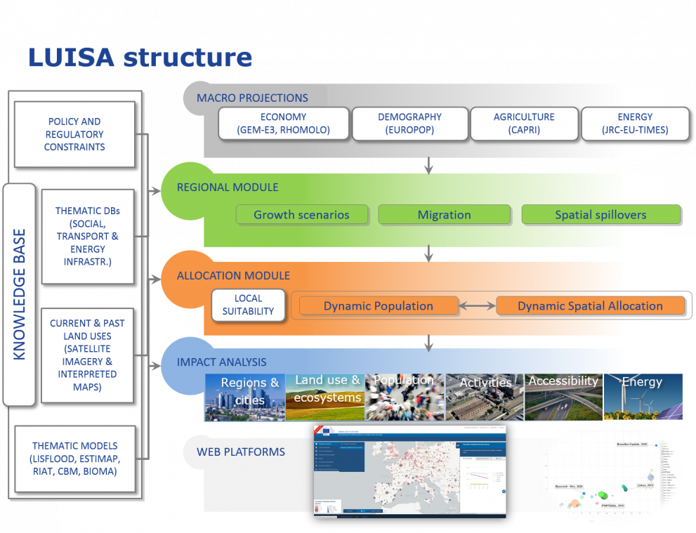
The platform is based upon the integration of a suite of models, and is centred on the concept that the consequences of “where” and “when” a measure is taken are as important as those related to “what” and “how much” it is about.
The concept applies for example to infrastructural investments, since the efficiency of a transport hub or of an energy network greatly depends on its geographical location and actual neighbouring socio-economic conditions. Other examples are the evaluation of regional subsidies, the setting of binding regulations, the avoidance of impacts of climate extremes, etc.
LUISA allocates (in space and time) the demand and supply of resources (biotic and abiotic, including primary energy sources), the settlement of socio-economic activities (e.g. housing, industry, services, tourism, etc.) and the setting of infrastructures (e.g. for transport, energy, etc.).
Biophysical suitability, policy and regulatory constraints and targets, economic criteria and other factors are dynamically considered in LUISA for the allocation of activities and resources. Figure 1 depicts the overall LUISA workflow.

Macro-economic variables are derived from specialised sectoral models (such as RHOMOLO, GEM-E3, CAPRI, POLES, etc.), while geo-spatial models (such as TRANSTOOL, LISFLOOD, Regional Climate Models, BIOMA, etc.) provide thematic physical and geographical layers. Overall long-term demographic (trends and migrations) and economic projections are given by Eurostat and ECFIN – ensuring the consistency of assumptions. Table 1 gives the overview of policy-related models linked in LUISA.
| Model | Sector/Policy |
|---|---|
| EUROPOP 2010 | Demography |
| GEM-E3 | Economy |
| RHOMOLO | Regional economy |
| LEITAP-IMAGE | Economy |
| CAPRI | Agriculture |
| G4M, CBM | Forestry sector |
| TRANSTOOLS | Transportation |
| POLES, PRIMES, JRC-EU-TIMES |
Energy sector |
| LISFLOOD/QUAL | Water quality |
| GREEN/EPIC | Water quality |
| RIAT | Air quality |
| ESTIMAP + | Ecosytems services |
The newly implemented regional module allows the endogenous generation of socio-economic scenario, derived from wide National or European projection of parameters from e.g. ECFIN and EUROSTAT.
The final output of LUISA is in the form of a set of spatially explicit indicators that can be grouped according to specific themes (bio-physical, ecological, economic, and social) which as referred to as ‘land function’. The indicators are projected in time until typically year 2030 or 2050, and can be represented at various levels (national, regional or other). Table 2 illustrates how the indicators are thematically grouped.
| Function | Division | Class |
|---|---|---|
| Economic | Employment | 50 + indicators |
| Sectoral GVA | ||
| Social | Recreational and cultural services | |
| Provision of products | Water | |
| Food and biofuels | ||
| Wood biomass | ||
| Settlements and infrastructures | Residential | |
| Industry, commerce | ||
| Transport, technological infrastructures | ||
| Regulation services by (natural) physical structures and processes | Mediation of nuisances | |
| Mediation of flows | ||
| Maintenance of physical, chemical, biological conditions | ||
| Atmosphere composition and climate regulation | ||
| Ecosystems and biodiversity | Biodiversity conservation | |
| Maintaining ecosystems |
