When disasters like floods, wildfires or cyclones hit, the Copernicus Emergency Management Service (CEMS) – operated by the JRC – is often called on to help assess the damage.
Since late last year, CEMS can counts on new aerial means to bring data that complements satellite imagery. These comprise both planes and drones to capture images from above.By the end of 2023, every EU country should become covered in case of a disaster.
FairFleet GmbH, which provides drone services and information data analysis, and a consortium of mapping planes providers, led by CGR SpA, are currently operating in several EU countries and collecting aerial images at request of CEMS experts.
Drones and planes vs satellite imagery
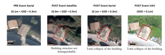
Cloudy weather and the time interval between successive satellite passages hamper collection of high-quality images. Alternatively, drones and planes flying at low altitudes can overcome this limitation.
These aerial images are also much more accurate than those from satellites. The superior resolution compared to satellite imagery enables thorough analysis of landscapes, buildings, and ground features, ultimately leading to more accurate disaster preparedness, impact assessments and recovery efforts.
Disaster assessment and recovery: success stories
Aerial images have been used to identify the location and exact extent of landslides, to map biomass losses to forest fires or to work on preparedness activities for dam break scenarios.
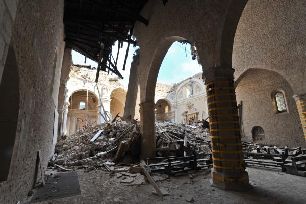
In November 2022, after a cyclone-triggered landslide caused a lot of damage on the Italian island of Ischia, the Italian Civil Protection made use of the new CEMS service. Aerial images (10cm spatial resolution) complemented three-dimensional information about the surface characteristics generated using the Light Detection and Ranging (LiDAR) method. This information offered key support to local response strategies.
Later in March 2023, after a forest fire in the La Balsa del Pulguer Natura 2000 site in Spain was extinguished, the Spanish General Directorate of Civil Protection and Emergencies (DGPCE) activated the service. By combining aerial and satellite data, CEMS experts estimated the biomass damage and the value of the lost ecosystem services.
A similar work was also performed in May 2023 to accurately evaluate the impact of 2022 forest fires on vegetation and infrastructures in the Portuguese Serra da Estrela National Park. These insights on affected areas helped national authorities estimate the necessary recovery efforts.
Also in May, heavy floods hit the Emilia Romagna region of Italy and CEMS experts calculated the damage extent. Later in June, thanks to detailed images from drones, they pinpointed the location and estimated the volume of the landslides, showing the impact they had.

The key role of aerial precision in the future of disaster assessment
The ability to perform thorough analysis of changes to landscapes, buildings, and ground features supports more accurate disaster impact assessments. In times when climate change is expected to increase the frequency and severity of natural hazards, such assessments become even more important.
By the end of 2023, JRC expects to be able to count on more drone pilots supporting the aerial assessments - ensuring coverage of every EU country. This will help CEMS experts to provide emergency responders and site managers with highly accurate information, improving their understanding of emergency situations.
Planes and drones may serve other uses soon like monitoring compliance with EU regulations, mapping buildings damaged by earthquakes, etc. The adaptability of these aerial means makes them valuable assets in a wide range of emergency, risk reduction scenarios and beyond.
This year’s edition of the Copernicus Emergency Mapping Service (CEMS) annual conference will bring together media, researchers, practitioners, and others looking for ways to integrate disaster risk management (DRM) data in their work. Participants will learn more about CEMS’ early warning and monitoring systems and how to collect and personalise disaster risk data.
Background information
The Copernicus Emergency Management Service (CEMS) belongs to the broader Copernicus EU programme. It serves different groups like regional, national, European, and international organisations that work in civil protection and humanitarian aid.
CEMS has three main lines of work: mapping, early warning and monitoring (on floods, forest fires and droughts) and population exposure analysis. The CEMS mapping team uses satellite and aerial images to create accurate maps during all phases of disaster management.
A part of the CEMS mapping team produces reference maps in the aftermath of a disaster showing the situation before, a first estimate map, a map outlining the extent of the disaster (rough or detailed), and a map grading the magnitude of the damage and its impact.
Another group of CEMS mapping experts work on risk and recovery maps that assess risks before a disaster or monitoring recovery after one. This includes prevention, preparedness, and recovery efforts.
The full work of CEMS mapping teams is available in the dedicated activation pages for rapid maps or for risk and recovery maps.
Related links:
Introducing the Aerial Component to Improve CEMS Mapping Products
Details
- Publication date
- 25 September 2023
- Author
- Joint Research Centre
- JRC portfolios