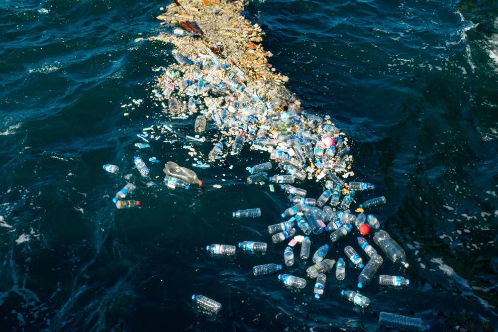
Marine littering has grown into a global environmental problem, and is recognised as an urgent priority on international sustainability agendas. A full 80% of this litter is plastic. Continued efforts in mapping its presence in water surfaces have produced important results, such as the discovery of the so-called plastic island in the middle of the Pacific and Atlantic Oceans. Due to the vastness of the ocean, however, field measurements remain limited. This makes satellite-based observations one of the best hopes for large-scale monitoring of marine pollution.
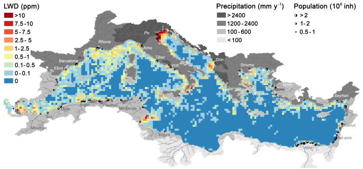
In a work published today in Nature Communications, a group of international researchers, including JRC, established that accumulation patches of floating litter (also called windrows) can be identified in images taken by Copernicus satellites. By automatically analysing more than 300 000 remote sensing images of the Mediterranean Sea, researchers identified thousands of litter windrows. This new analysis made it possible to detect the most polluted areas, determine seasonal variability patterns and the extent of land-based emissions.
Looking for a needle in a haystack
A team of international space companies and research institutes from six countries, funded by the European Space Agency, assessed the viability of using litter windrows as indicators for monitoring marine litter. They analysed a six-year historical series of 300 000 satellite images, scanning the entire Mediterranean Sea every three days with a spatial resolution of 10 metres, in search of litter. For this, they relied on Sentinel-2 satellites, part of the EU’s Copernicus Programme. Finding small litter windrows on the ocean surface is like looking for a needle in a haystack; a task only made possible by using supercomputers and advanced search algorithms.
The team discovered thousands of litter windrows, ranging from a few hundred metres to 20 kilometres long. They then matched these findings with model data on the hydrological conditions in the Mediterranean Sea, provided by the JRC, which helped explain the distribution and accumulation patterns of the litter detected. This allowed the team to create the most detailed map of marine litter pollution to date. Even though the satellites used were not specifically designed to detect litter, they enabled scientists to identify the most polluted areas and major changes over weeks and years.
Mapping more than litter...
Deploying satellites specifically designed to monitor ocean plastics could drastically improve detection capabilities and allow researchers to identify floating objects as small as one metre in size. This could be a real game-changer in the fight against plastic pollution. Improved monitoring can help pinpoint the most polluted areas and help identify its main sources. In turn, this could facilitate clean-up operations, making the oceans cleaner for all. Furthermore, this could help tackle other important issues, such as oil spills, loss of cargo, or aid search and rescue tasks at sea.
Background
Plastic pollution of oceans and seas is a major public concern. Several EU policies and actions have been put forward to address the ever-growing plastic challenges, from sectorial policies, such as the Single Use Plastic Directive, to overarching environmental legislation, such as the Marine Strategy Framework Directive, and the EU Zero Pollution Action Plan or EU Green Deal.
Monitoring marine litter levels and distributions is particularly challenging and resource-intensive for public authorities. Developing new methodologies based on semi-automatic analysis of remote sensing images would dramatically change our understanding of this pervasive type of pollution and allow more cost-effective management options.
Details
- Publication date
- 14 June 2024
- Author
- Joint Research Centre
- JRC portfolios


