New non-interactive calls
The PVGIS apps have been upgraded to improve the performance of the non-interactive service. The new non-intercative calls are:
https://re.jrc.ec.europa.eu/api/printhorizon?lat=45&lon=8 [PVGIS 5.1]
instead of:
https://re.jrc.ec.europa.eu/pvgis5/printhorizon.php?lat=45&lon=8 [PVGIS 5]
The former calls will be temporally redirected, but we encourage the users to start using the new calls since they include a higher rate limit of 25 calls per second.
The name of the apps and their inputs remain the same. Only, the following inputs have been homogenized to keep consistency between all the apps:
- outputformat, outputformatchoice, format -> outputformat
- endyear, finalyear -> endyear
Bug fixes
The following list of bugs reported by the users have been fixed:
- General bugs
- PVGIS 5 did not work over Senegal (-17.5 < lon < -12.5, 12.5 < lat < 15).
- Convergence problems during the optimization of slope and azimuth near the equator.
- Reduced PV production (around 50%) near the equator with negative optimum slopes.
- PVGIS-COSMO was lagged one hour. After correcting this issue, all the results obtained with COSMO may change, especially those from the daily and hourly tools. This lag was also the cause of the incorrect optimal azimuth (too negative values) obtained with PVGIS-COSMO.
- PV grid-connected & Tracking PV bugs
- (non-interactive). No output when vertical_axis = 0.
- PV off-grid bugs
- (non-interactive). hourconsumption parameter not working.
- Daily data bugs
- Local time correction lagged 1 hour in negative time zones.
- No output when disabling horizon shadows.
- Calculations on fixed planes were made with the whole temporal coverage of the solar radiation database selected, but those on sun-tracking planes were restricted to 2007-2015.
- Hourly data bugs
- Incorrect time format when using PVGIS-SARAH over Asia (negative minutes).
- TMY bugs
- Wind direction angle shifted 180 degrees.
- TMY calculations were made with the user-defined period, but cooling/heating degree days were always calculated from 2005 to 2014.
New JSON output
All the apps include a new JSON output to improve the integration of PVGIS in other web tools. This new output can be accessed either from the website or from the non-interactive calls (outputformat = json). All the JSON files contain three main fields:
- inputs: summary of the inputs, including the inputs set by the user and the default parameters of the app being used.
- outputs: results.
- meta: metadata of the inputs and the outputs (variable description and units)
The specific details the JSON files are described in the corresponding page of each tool. The following is an example of the JSON output of the PV grid connected tool:
{ "inputs": { "location": { "latitude": 45.809, "longitude": 8.632, "elevation": 223 }, "meteo_data": { "radiation_db": "PVGIS-SARAH", "meteo_db": "ERA-Interim", "year_min": 2005, "year_max": 2016, "use_horizon": true, "horizon_db": "DEM-calcualted", }, "mounting_system": { "fixed": { "slope": { "value": 30, "optimal": False }, "azimuth": { "value": 0, "optimal": False }, "type": "free-standing", }, {...} }, "pv_module": { "technology": "c-Si", "peak_power": 1, "system_loss": 14, }, "economic_data": { "system_cost": 10000, "interest": 1, "lifetime": 25, }, }, "outputs": { "monthly": { "fixed": { { "month": 1, "E_d": 2.59, "E_m": 80.15, "H(i)_d": 3.06, "H(i)_m: 94.98, "SD_m: 23.19, }, {...} }, {...} } "totals": { "fixed": { { "E_d": 3.63, "E_m": 110.33, "E_y": 1323.91, "H(i)_d": 4.67, "H(i)_m: 141.99, "H(i)_y: 1703.83, "SD_m: 12.91, "SD_y: 154.95, "l_aoi: -2.24, "l_spec: 1.16, "l_tg: -8.26, "l_total: -22.3, "LCOE_pv: 0.010 }, {...} }, {...} } }, "meta": { "inputs": { "location": { "description": "Selected location" "variables": { "latitude": { "description": "Latitude", "units": "decimal degrees" }, {...} } }, {...} }, "outputs": { "monthly": { "type": "time series" "timestamp": "monthly averages" "variables": { "E_d": { "description": "Daily energy production from the given system", "units": "kWh/d" }, {...}, }, {...} } } }
Updated default values
Solar radiation database (raddatabase)
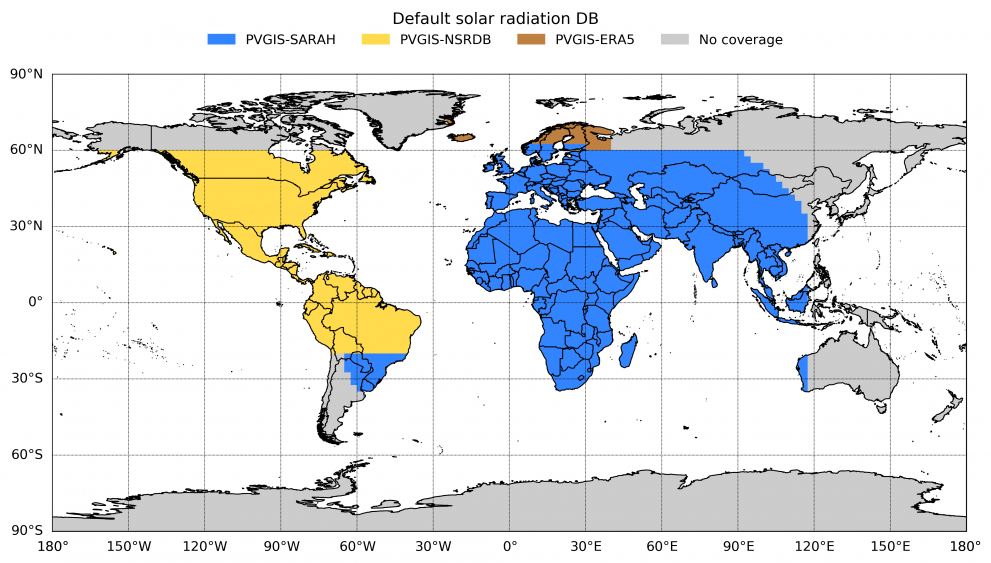
The new default radiation database is a combination of PVGIS-SARAH (Europe, Africa, Asia), PVGIS-NSRDB (Americas) and PVGIS-ERA5 (Nordic countries).

In the new default:
- PVGIS-ERA5 has been extended backward from (2010-2016) to (2005-2016).
- PVGIS-NSRDB has been extended backward from (2006-2015) to (2005-2015).
We encourage users to use the previous default database because these are the databases with the smallest uncertainty in each region. Regarding the former default databases:
- PVGIS-CMSAF (Europe, Africa). This database has a significantly larger uncertainty than SARAH and cannot be extended temporally any more. PVGIS-CMSAF will be removed in 2021.
- PVGIS-COSMO. ERA5 will remain as the only alternative in regions outside the coverage of satellite-based databases. PVGIS-COSMO will be removed in 2021.
Temporal coverage of the calculations (startyear, endyear)
In all the apps, the default value for non-interactive calculations has been set to the full temporal coverage available for the solar radiation database selected. This default has been also applied to those apps in which the temporal coverage cannot be modified by the user: PV grid-connected, tracking PV, and PV off-grid. The new results will vary particularly in the PV off-grid app (SHScalc), since the calculation period of PVGIS 5 was restricted to 2009-2013.
PV technology (pvtechchoice)
The new default for non-interactive calls is 'crystSi' instead of 'Unknown'.
Minor modifications
The nomenclature of output variables has been redefined in order to keep consistency between all the tools. The new nomenclature is detailed in the specific tab of each app. Other minor modifications are:
- PV grid-connected (PVcalc)
- The sign of the losses has been included in the outputs.
- The economic calculations have been included in the non-interactive calls. They are activated with pvprice=1. The PV electricity price has been accordingly added to all the output formats.
