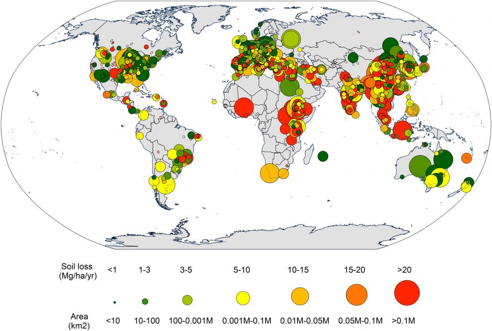
An international group of scientists, led by the EU Soil Observatory (EUSO) team at the JRC, have developed the first Global Applications of Soil Erosion Modelling Tracker (GASEMT), which aims to give a better understanding of the global application of soil erosion prediction models
GASEMT is an open access database that provides comprehensive insights into the state-of-the-art of soil-erosion models and model applications worldwide. This database will support the development of the country-based United Nations global soil-erosion assessment (as voted for at the Sixth Session of the Global Soil Partnership Plenary Assembly, 2018).
8,500 articles, 66 scientists, 25 countries, 2 studies, 1 database
To develop the database, 66 erosion modellers from 25 countries reviewed 8,500 peer-reviewed research articles on soil-erosion modelling published during the period 1994-2017.
This participatory network aimed to identify
- the processes and models most frequently addressed in the literature,
- the regions within which models are primarily applied,
- the regions which remain unaddressed, and why, and
- how frequently studies are conducted to validate/evaluate model outcomes relative to measured data.
This study and the results are published in Science of the Total Environment.
In a follow-up study, published in Environmental Research, the same group of scientists carried out a bibliometric analysis to investigate collaboration networks and citation patterns.
Global state-of-the-art in soil erosion modelling
The systematic literature review carried out to compile the GASEMT database and the follow-up statistical and bibliometric analysis provide data-driven insights into the global state-of-the-art in soil-erosion modelling for the first time.
The model selection, the scale of application and the validation/calibration process are important for the research in soil erosion modelling as they ensure more citations and greater attention from the research community.
The frequency of model applications inversely relates to erosion severity
The analysis suggests that industrialised and highly developed countries, generally in temperate latitudes with lower erosion rates, show a higher incidence of soil-erosion modelling studies.
The database reports fewer studies in less-developed, tropical, and subtropical countries where, ironically, modelling findings suggest greater exposure to erosive processes.
The challenge of the Global Soil Erosion Map
The findings suggest that unsustainable soil-erosion rates occur not only due to a lack of policy governance but, in many regions of the world, may also result from a lack of knowledge.
Policymakers and the scientific community now face the challenge of redressing this lack of knowledge by developing a Global Soil Erosion Map based on new region- and country-based modelling assessments supported by well-defined field-based data collection to validate/evaluate the results.
The JRC’s modelling experience in developing the Global Soil Erosion Modelling platform (GloSEM) makes it well placed to be a key player in the development of the new country-based UN global soil erosion assessment, by facilitating information acquisition and integrating national data to modelling.
The new Global Applications of Soil Erosion Modelling Tracker (GASEMT) lays the foundations for the further development of this assessment and mapping exercise.
Further information
- Soil erosion modelling: A global review and statistical analysis
- Soil Erosion Modelling: A Bibliometric Analysis
- GASEMPT - Global Applications of Soil Erosion Modelling Tracker
- EU Soil Observatory (EUSO)
- Global Soil Erosion Modelling platform (GloSEM)
Related Content
Soil erosion modelling: A global review and statistical analysis
Soil Erosion Modelling: A Bibliometric Analysis
GASEMPT - Global Applications of Soil Erosion Modelling Tracker
Details
- Publication date
- 21 April 2021
