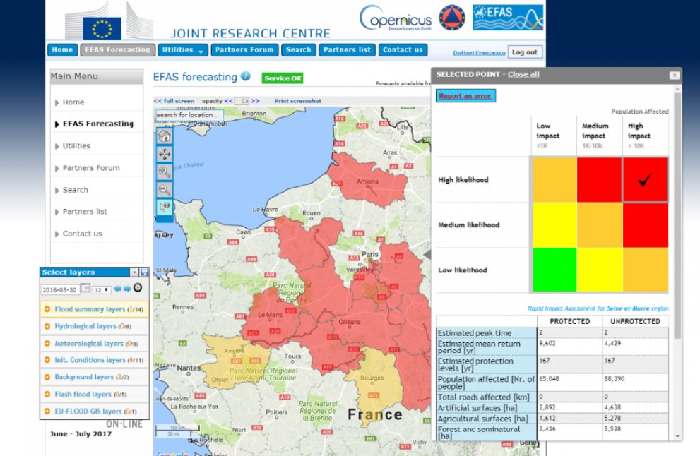
The JRC has developed a new forecasting tool to help disaster responders prevent the worst impacts of floods.
The first of its kind in operation, the tool adds near real-time impact assessments to existing forecasts, allowing authorities to prepare and focus resources well ahead of potential floods.
Following extensive testing, it has now been integrated into the Copernicus European Flood Awareness System (EFAS).
The EFAS already plays an important role as an early warning flood forecast service. By providing added value information to its users, such as predictions up to 10 days ahead for Europe’s major rivers, it helps countries to take action ahead of time.
However, predicting where floods are likely to happen is only part of the picture.
EFAS users, including national flood forecasting services, civil protection authorities and the European Commission’s Emergency Response Coordination Centre (ERCC), have previously relied on expert judgement or static information, such as flood risk maps prepared for an event of a certain magnitude, to predict a flood’s impact and take precautionary measures.
The JRC’s new tool allows the EFAS to calculate flood hazard and risk dynamically, based on the most recent forecasts, and to display the potential consequences in near real-time. Even when there are multiple flood events occurring simultaneously across the continent, the procedure is capable of producing results within one hour of the initial flood forecasts being produced.
The impact information includes an estimate of potentially affected people, economic damage, critical infrastructure and a list of the major urban areas impacted by the forecasted flood event. It will help emergency services to better allocate available resources to mitigate a flood’s impacts.
Making the right decisions on where to strengthen flood defences or when to evacuate those at risk is essential to protect lives and livelihoods from the increasing instances of flooding across the continent.

How does it work?
The EFAS provides flood forecasts twice per day. If these forecasts predict a high probability of flooding, the JRC’s new rapid risk assessment procedure is executed as follows:
First, the sections of river likely to be affected and the likely magnitude of flooding in different areas are defined.
Then, depending on the predicted flood magnitude, high-resolution flood hazard maps for the sections of the rivers are merged together to create a hazard map of the entire area.
Finally, the hazard maps are combined with exposure data such as land use, building types, road networks and information on how vulnerable the exposed assets are, to assess the impact on people, infrastructure and the economy.
The tool will be continuously improved, including applying additional risk scenarios and more detailed critical infrastructure data such as hospitals or airports. Furthermore, the new tool is now used to increase the timeliness of the satellite based flood monitoring and mapping currently provided by the Copernicus Emergency Management Service Mapping.
Finally, it is foreseen to expand the tool to the global scale, by combining it with the Copernicus Global Flood Awareness System.
Scientists working on the development of the rapid risk assessment procedure provide a comprehensive description of the tool in Natural Hazards and Earth System Sciences.

Background
The disastrous floods in the Elbe and Danube rivers in 2002 illustrated a lack of preparedness and communication between all different stakeholders, complicating planning and organization of aid. In response to this event, the European Commission initiated the development of a European Flood Awareness System (EFAS) to increase the preparedness for floods in Europe.
The aim of EFAS is to gain time for emergency measures before major flood events strike, particularly for trans-national river basins both in the Member States as well as on European level.
This is achieved by providing complementary, added value information to the national forecasting services and by keeping the ERCC informed about ongoing floods and about the possibility of upcoming floods across Europe.
EFAS has been fully operational since October 2012 under the umbrella of the Copernicus emergency management service.
The EU space programme Copernicus is a leading provider of Earth observation data across the globe. It processes data and provides users with reliable and up-to-date information through a set of services in six thematic areas: land monitoring, marine monitoring, atmosphere monitoring, climate change, emergency management response and security.
Copernicus helps save lives at sea, improves our response to natural disasters such as earthquakes, forest fires or floods, and allows farmers to better manage their crops, collects data from earth observation satellites and ground stations, airborne and sea-borne sensors.
Related Content
European Commission’s Emergency Response Coordination Centre (ERCC)
Research article: An operational procedure for rapid flood risk assessment in Europe
Details
- Publication date
- 21 September 2017
